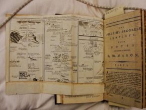
In the late eighteenth century, an edition of John Bunyan’s The Pilgrim Progress was published with a map tucked away between the pages right before the beginning of the text. Nowadays, the map is a recurring part of many novels, especially in the fantastical genre. These maps have in common that they are accompanying a story that is set in an imaginary world, thus increasing the authenticity of these worlds by depicting it in a way that is mostly associated with precision and trustworthiness.
But a lot has changed since the eighteenth century. In this paper, I’m interested in the variation of the role a map would have played to a reader of the eighteenth century edition of The Pilgrim’s Progress as compared to the map as a tool for a contemporary audience. For this comparison I will focus on maps of perhaps one of the best known fantastical worlds in literature: Middle-earth, created by J.R.R. Tolkien. The books about this world have always been popular, which has only increased thanks to the recent movie adaptions. Thanks to this popularity and the huge fan-base, among the maps depicting Middle-earth are some good examples of what is possible today. Furthermore, it has been argued that Tolkien laid the foundations here:
Tolkien set the trend for maps and prehistory, establishing a pattern for the quest narrative in which the portal is not encoded solely in the travelogue discovery of what lies ahead,but in the insistence that there is past and place behind. (Mendlesohn: 14)
Therefore, my main question will be: what is the role of the map as a paratext to an eighteenth century version of The Pilgrim’s Progress as compared to the role of maps depicting Middle-earth for a contemporary audience?
First, I will be looking at the most common example of maps to have accompanied The Lord of the Rings, the magnum opus of Tolkien. This is, just like the map with The Pilgrim’s Progress, a map accompanying the novel, depicting the road the protagonists would have to travel in the following pages. But, as will be shown, there are some differences. This gap will become even bigger when we jump to the digital era and take a look at what maps can bring to a story and its readers nowadays. Because of the new possibilities that have opened up with the introduction of digital maps, it is to be expected that people approach and make use of this kind of map in a rather different way than the static ones that are printed with a text.
A map to the Celestial City and one to Mordor
Bonnie Mak has linked the development of paratext to the rise of universities in the 12th century. She says about the act of reading before this rise:
Reading, understood as a spiritual exercise, emphasized the slow and steady contemplation of a single text. With this approach, readers were less likely to be in need of reminders of their location in the larger context of the book. (Mak: 43)
Then, the development of universities “fostered analytical modes of engagement with text” (Mak: 43). This encouraged the development of paratext fostering the reading process, helping scholars in their studies and fabricating – both visually and verbally – a context for reading.
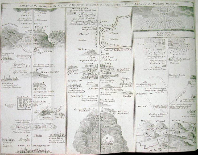
Looking at the foldout map at the beginning of The Pilgrim’s Progress, it becomes clear that it is mainly used as a depiction of Christian’s journey to the Celestial City. The map shows the road leading there from the city of destruction in a clear, straight line. This line is only broken at the top of the page, where the reader has to jump back down to the bottom and continue reading in the column to the right. The emphasis is entirely on the journey of Christian and little is depicted that lies outside it. In this, the map clearly differs from a regular map where the world would be depicted in its entirety. Nathalie Collé-Bak recognized as one of the roles of illustrations in the narrative that “a reader at the beginning of the nineteenth century could even ‘read’ The Pilgrim’s Progress mainly or solely through its illustrations” (Collé-Bak: 87). I would argue that this was already the case at the end of the eighteenth century, since the map that accompanied the edition that was published around 1790 can also be seen as a kind of abstract of the text that will follow. Small descriptions and drawings along the road tell us what happened to Christian on each part of his journey. It seems completely plausible that this map was meant as a tool for the reader of The Pilgrim’s Progress to keep track of Christian’s Progress during the reading process.
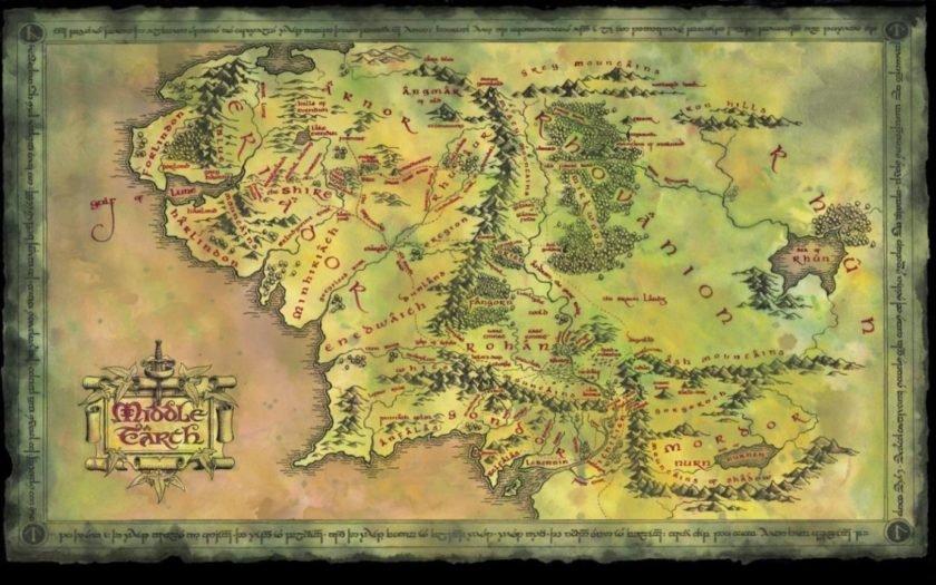
The map at the beginning of most editions of The Lord of the Rings can be used in more or less the same way while reading the text. Although the map doesn’t mention specific episodes of the narrative like the one with The Pilgrim’s Progress, it is perfectly possible to follow the progress of the ‘Fellowship of the Ring’ by constantly returning to the map and looking for the names of the places the Fellowship is journeying through. However, this map does depict Middle-earth in its entirety. It is not solely focused on the journey that will be described in the remainder of the novel. In this, it looks more like a ‘regular’ world-map than the foldout one with The Pilgrim’s Progress. The road from The Shire – where Frodo, the main protagonist, sets out on his journey – to Mordor where ‘The One Ring’ has to be destroyed isn’t depicted as a straight line from start to destination.
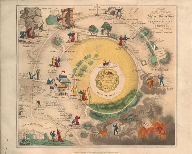
Of course, the notion that Christian has to walk a straight line and must not wander from this pad in his journey to the Celestial City is in itself an important aspect of the text. Other editions of maps show this same aspect, although some artists have solved the issue of having to depict the map in three columns by converting it to a circular way. It seems to be an important notion that with The Pilgrim’s Progress, the journey is the key element of the novel and the aspect that has to be emphasized to the reader, whereas with The Lord of the Rings the world itself is also, if not more, important.
This can also be applied to the narratives. In The Lord of the Rings, the notion of an unknown world is a big contributor to Frodo’s restlessness which helps to persuade him of leaving the Shire:
Maps also move the characters in the Tolkien trilogy to seek adventure: ‘Frodo began to feel restless, and the old paths seemed too well-trodden. He looked at maps, and wondered what lay beyond their edges: maps made in the Shire showed mostly white spaces beyond its borders. (Muehrcke: 324)
We, the readers, know that there is indeed a lot more out there, because at the beginning of the novel we are given a more extend map, in which the Shire is actually no more than just a very tiny part of the entirety that is Middle-earth. Just as Frodo’s interest is aroused by the white areas on his own map, so the reader is given a map that shows that there is a whole world outside of the story. This is consistent with what Farah Mendlesohn says about the construction of a believable world: “If one turns the corner of the street, one will not run off the page of the author’s speculation.” (71)
This is different with The Pilgrim’s Progress. Maps don’t play a role in the narrative itself. This would be kind of strange, since it would make Christian’s journey a whole lot easier and wouldn’t fit in the idea of avoiding temptation in order to get your sins removed. Christian is not supposed to get interested in what lies outside the borders, he is supposed to stay on the path. The depiction of the map is doesn’t seem to invite the reader to wonder what lies beyond its boundaries. The focus is solely on the journey to the Celestial City.
The map in the digital era
One of the major aspects of digital culture is its accessibility. As a reader, you are no longer bound to one map. Search for ‘Pilgrim’s Progress map’ on Google and there are plenty of different maps to choose from. Although most are versions of the straight line or the circular one, there are some interesting and beautiful examples to be found this way.
But digitalization has brought more than just online accessible maps that can be downloaded, printed and then used in the same way as the ’old’ maps. Mak noted that “Computational technologies open new avenues for the transmission of information.” (62) Not only have they opened up new avenues, older ones have also been updated. The digital era has introduced many new possibilities of mapmaking, also including the reader in the process. The map is no longer a static entity, fixed to the borders of the page. Mak said about the digital page that “a single digitally encoded pagina may appear to stretch beyond the physical dimensions of the hardware, consequently demanding that the reader scroll in different directions to navigate its borders.” (Mak: 62)
With ‘old’ maps that are fixed to the page, the reader could choose to follow the character’s journey as the text presented it, or to focus on whatever part of the map arrested their interest. With the map of Middle-earth, this means a non-linear reading habit, because readers were able to wander of the road the Fellowship was taking and explore more of the world, also reading names of forests and rivers the Fellowship never even crossed through. And even with The Pilgrim’s Progress, whose map encourages reading in one direction, there was a certain amount of freedom for the reader to skip over aspects of the road, or go back a little to remember what had already happened so far. The simple act of going back to the map to look up some passages and not others already entails selective, and thus interactive, reading.
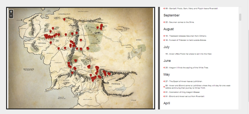
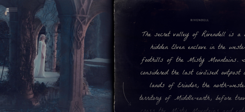
This interactive aspect to map-reading has increased with the digital map. A good example of what is possible nowadays is part of an advertising campaign for the last Hobbit movie. This features a Middle-earth version of Google-maps, of which I have includes some examples below. As with the ‘regular’ Google-maps, it is possible to scroll across the screen and zoom in on certain aspects. Unfortunately, street view cars haven’t reached Middle-earth yet, but it is possible to ‘step’ into a specific part of the map. In the provided example, this is Rivendell. After the screen that is depicted in the appendix, the reader is given information about this location, images from the film move across your screen while you scroll past them and there are even little games to be played.
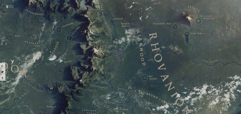
This map does much more than simply depicting Middle-earth. It also gives readers the possibility to choose for themselves on what part they will focus their attention, where they would like to acquire more information or if they feel like playing a game associated with the story. This last remark – associated with the story – is interesting, because all these extra features seem to be focused on the narratives in The Lord of the Rings and The Hobbit. In this way, the emphasis of the map returns to the journey that is described in the novel, as in the case of the map of The Pilgrim’s Progress. Once again, markers along the way show where the protagonists went and textual markers tell more about what they actually did there. It seems almost as if technology has placed a filter over the existing maps of Middle-earth, because we still have the same map depicting the whole world, but with added emphasis on the places where something remarkable happened.
Still, this focus on the journey is less restricting than in the case of the discussed foldout map of The Pilgrim’s Progress. The journey is inscribed in the map, but doesn’t determine its shape. And of course, the possibility to scroll in different directions to navigate the borders of a digital map also arouses that curiosity noticed by Muehrcke, to what lies beyond these borders. It is quite satisfying to click on the map and discover the possibility of dragging it across your screen, thus discovering much more of Middle-earth than you were able to see in the first instance.
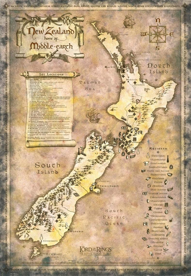
To conclude this part about what digital maps can bring to the reader, I’ve included two last examples at the bottom of this paper. One is a rather simplified version of the idea of a filter that is laid about the existing Middle-earth map; the other depicts a part of our own world as Middle-earth: it displays the filming locations of The Fellowship of the Ring. This is an excellent example of how maps can contribute to what Stijn Reijnders calls media pilgrimages:
In recent years an increasing number of studies have investigated the attraction for tourists of locations that are associated with popular films, books, songs and TV series. For instance, […] the ‘set jetters’ who visit New Zeeland because The Lord of the Rings was filmed there. (Reijnders: 3-4)
This gives readers and fans yet another way of experiencing Middle-earth through a map, and even enables them to actually visit the locations themselves.
Conclusion
It seems that the differences that were found between the foldout-map in The Pilgrim’s Progress and the map in The Lord of the Rings are for an important part due to differences in the text. While both allow the reader to follow the journey that is written down, and in this fulfill the role that Mak has recognized for paratext – helping the reader keep track of where they are in a text – the emphasis with The Pilgrim’s Progress is on the journey, while with The Lord of the Rings it is on the world.
With the introduction of digital technology, the possibilities for mapmakers to introduce the reader to the world they’re depicting have also increased. Information is no longer limited to the flat page, but can also be placed outside of the borders (encouraging the reader to scroll past these borders) or on another level (encouraging the reader to zoom in or follow a link to a different page). As has been shown, in the digital era maps have become more interactive. It could be said the reader is constructing his own map, by choosing where to scroll or zoom, instead of being limited to one plain as with the ones presented in a book. Thus the map seems to have evolved from something that can be folded out to something that the reader can scroll about.
Bibliography
Collé-Bak, Nathalie. “The Role of Illustrations in the Reception of The Pilgrim’s Progress.” Reception, Appropriation, Recollection.Bunyan’s Pilgrim’s Progress. Ed. W.R. Owens and Stuart Sim. Oxford: Peter Lang, 2007. 99-126. Print.
Mak, Bonnie. How the Page Matters. Toronto: University of Toronto Press, 2011. Print.
Mendlesohn, Farah. Rhetorics of Fantasy. Middletown: Wesleyan University Press, 2008. Print.
Muehrcke, Philip and Juliana Muehrcke. “Maps in Literature.” The Geographical Review Jul. 1974: 317-338. Print.
The Hobbit: The Desolation of Smaug – A Journey Through Middle-earth.
About
This is a paper I wrote for my research master literary science at VU University, for a class on The Pilgrim’s Progress. I chose a version with a beautiful foldout map, and wrote about this map in comparison to the role of maps in Tolkien’s work.
During my masters, I specialized in fantasy literature, and therefore wrote a lot about Tolkien (although I have to admit I graduated with a thesis on Terry Pratchett. He passed away while I was writing it. It like to think it had nothing to do with what I was writing about him). I work in online marketing now – for a herb garden and a provider of yoga vacations – but my love for the academic side of fantasy never left. That’s why I’m also working on an online knowledge base on the paranormal in the real world.
I recently started blogging about my world building research. A Dutch version of this paper (Midden-aarde kaart) was uploaded recently, and this motivated me to share the original English versions of my work as well. Hope you enjoy reading it More is to follow!